Where to stay in Kyoto
We took a 4-day plan of Kyoto's main sights and timed it from each neighbourhood you could stay in.
About 5 minutes less in transit than Downtown, where most visitors stay.
Travel time from each neighbourhood
| Stay near | Day 1 | Day 2 | Day 3 | Day 4 | Total |
|---|---|---|---|---|---|
| Nijo | 40 | 25 | 50 | 30 | 145 min |
| Downtown | 20 | 35 | 70 | 25 | 150 min |
| Kyoto Station | 35 | 50 | 65 | 15 | 165 min |
| Gion & Higashiyama | 20 | 45 | 100 | 25 | 190 min |
| Okazaki | 40 | 25 | 90 | 35 | 190 min |
| Fushimi Inari | 50 | 65 | 95 | 5 | 215 min |
| Arashiyama | 85 | 75 | 40 | 40 | 240 min |
| Kinkaku-ji | 85 | 65 | 40 | 55 | 245 min |
| Fushimi Sake District | 53 | 75 | 115 | 15 | 258 min |
On the map
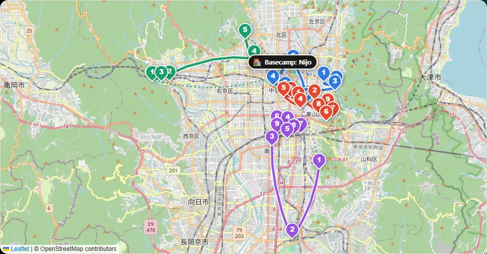
The neighbourhoods
Nijo
Close by
- Nijo Castle
- Kyoto Imperial Palace
Food nearby
- Kyoryori Fujimoto Kyo-kaiseki
- Marutamachi Junidanya Street snacks
- SHUHARI KYOTO Matcha panna cotta
Downtown
Close by
- Nishiki Market
- Pontocho
- Shinkyogoku Shopping Street
Food nearby
- TEAWAVE Kyoto Matcha pancakes & pudding
- Ramen Sugichiyo Kyoto ramen
- Mendokoro Janomeya Tori soba (chicken ramen)
Kyoto Station
Close by
- Kyoto Tower
- To-ji Temple
- Higashi Hongan-ji
Food nearby
- Shinpuku Saikan Honten Kyoto ramen
- Honke Daiichi Asahi Takabashi Kyoto ramen
- Kaidashi Men Kitada Shellfish broth ramen
Gion & Higashiyama
Close by
- Kiyomizu-dera
- Sannenzaka
- Yasaka Pagoda (Hokan-ji)
Food nearby
- Sohonke Yudofu Okutan Kiyomizu Yudofu (simmered tofu)
- Yuba Ryori Higashiyama Yuzu Yuba (tofu skin)
- Izuju Mackerel pressed sushi
Okazaki
Close by
- Heian Shrine
- Nanzen-ji
- Eikan-do Zenrin-ji
Food nearby
- Honke Nishio Yatsuhashi Main Store Street snacks
- Nanzenji Junsei Yudofu (simmered tofu)
- Honke Nishio Yatsuhashi Main Store Street snacks
Fushimi Inari
Close by
- Fushimi Inari Taisha
- Tofuku-ji
Food nearby
- Omiya Mackerel pressed sushi
Arashiyama
Close by
- Arashiyama Bamboo Grove
- Tenryu-ji
- Togetsukyo Bridge
Food nearby
- Dashi to Kome MUKU Arashiyama Dashi breakfast set
- Kyotsukemono Mori Arashiyama Street snacks
- Yudofu Sagano Yudofu (simmered tofu)
Kinkaku-ji
Close by
- Kinkaku-ji
- Ryoan-ji
- Ninna-ji
Food nearby
- Toyouke Chaya Yudofu (simmered tofu)
- Kyotsukemono Tomikawa Street snacks
- Gontaro Kinkakuji Herring soba
Fushimi Sake District
Close by
- Gekkeikan Okura Sake Museum
- Kizakura Kappa Country
- Jikkokubune Boat Ride
Food nearby
- Gekkeikan Okura Sake Museum Bar
- Kizakura Kappa Country Bar
- Ginjo Shubo Aburacho Bar
Change the plan and the numbers change with it
Add the places you want, change the days or the pace: the stay advice is worked out again for your own trip.
Open this plan and make it yours →Questions
Where should I stay in Kyoto on a first trip?
Stay near Nijo or Downtown. About 5 minutes less in transit than Downtown, where most visitors stay.
Should I split my stay in Kyoto?
Not for this plan. Moving hotels takes about 90 minutes with check-out and check-in, more than it would save.
How do I get to the airport on the last day?
Airport: JR Haruka express from Kyoto Station to Kansai Airport (about 75 min); Itami by limousine bus (about 55 min).
The plan: our sample 4-day trip of Kyoto, built from the sights most visitors go to.
Travel minutes: typical public transport times, estimated. We are checking them against timetables.
Map data © OpenStreetMap contributors
Updated 2026-11-17