Where to stay in Hapcheon & Geochang
We took a 3-day plan of Hapcheon & Geochang's main sights and timed it from each neighbourhood you could stay in.
About 11 minutes less in transit than Haeinsa & Gayasan, where most visitors stay.
Travel time from each neighbourhood
| Stay near | Day 1 | Day 2 | Day 3 | Total |
|---|---|---|---|---|
| Geochang | 10 | 120 | 50 | 180 min |
| Haeinsa & Gayasan | 120 | 10 | 61 | 191 min |
| Hapcheon town & lake | 100 | 122 | 5 | 227 min |
On the map
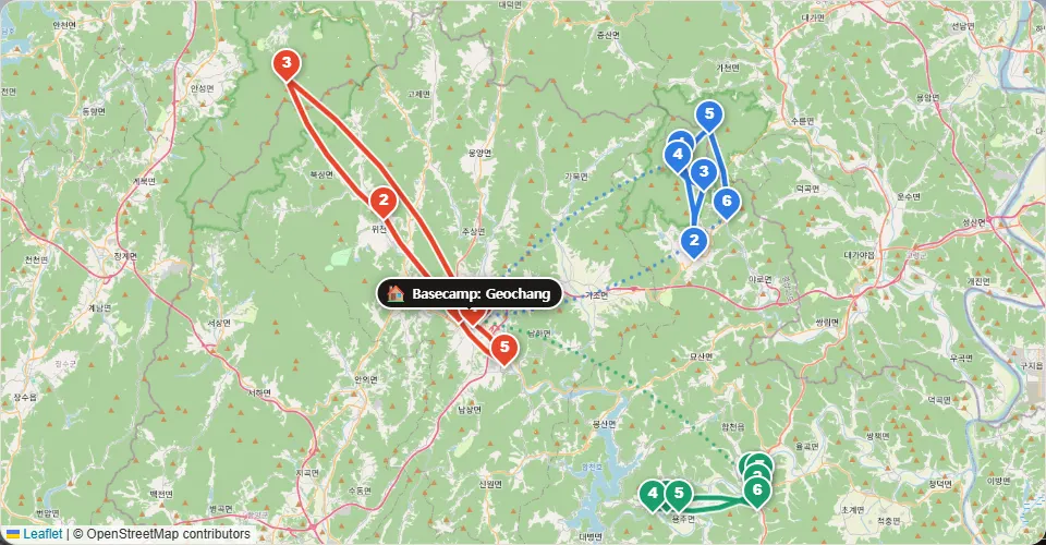
The neighbourhoods
Geochang
Close by
- Suseungdae Valley
- Geochang Changpowon Garden
- Deogyusan Mountain
Where locals eat nearby (card payment data)
- Dongbarihaejanggukseolreongtang Soup & stew
- Changseong Chinese
- Dangye Sikdang Noodles & dumplings
Haeinsa & Gayasan
Close by
- Haeinsa Temple
- Gayasan Sori-gil Trail
- Gayasan National Park
Where locals eat nearby (card payment data)
- Geumgwan Sikdang Home-style set meal
- Daegam Jip Home-style set meal
- Jonggugidumari Chikin Fried chicken
Hapcheon town & lake
Close by
- Hapcheon Film Theme Park
- Hwangmaesan County Park
- Hapcheon Lake
Where locals eat nearby (card payment data)
- Daesikhanumyeongga Korean BBQ
- Uyeonjeong Sikdang Home-style set meal
- Sigolttukbaegi Korean
Change the plan and the numbers change with it
Add the places you want, change the days or the pace: the stay advice is worked out again for your own trip.
Open this plan and make it yours →Questions
Where should I stay in Hapcheon & Geochang on a first trip?
Stay near Geochang or Haeinsa & Gayasan. About 11 minutes less in transit than Haeinsa & Gayasan, where most visitors stay.
Should I split my stay in Hapcheon & Geochang?
Not for this plan. Moving hotels takes about 90 minutes with check-out and check-in, more than it would save.
How do I get to the airport on the last day?
Leaving: express bus from Geochang, about 3 h 30 min to Seoul
Leaving: about 1 h by car to Dongdaegu Stn, then KTX about 1 h 50 min to Seoul
The plan: our sample 3-day trip of Hapcheon & Geochang, built from the sights most visitors go to.
Travel minutes: road routing on OpenStreetMap (November 2026), door to door with parking.
Restaurants: ranked by BC Card payment data in each neighbourhood.
Map data © OpenStreetMap contributors
Updated 2026-11-17